CHAPTER I.
CHAPTER II.
CHAPTER III.
CHAPTER IV.
CHAPTER V.
CHAPTER VI.
CHAPTER VII.
CHAPTER VIII.
CHAPTER IX.
CHAPTER X.
CHAPTER XI.
CHAPTER XII.
CHAPTER XIII.
CHAPTER XIV.
CHAPTER XV.
CHAPTER XVI.
CHAPTER I.
THE
CROWN OF THE CONTINENT.In
the northwest corner of the Territory of Wyoming, about half way
between the Mississippi River and the Pacific Ocean, and in the same
latitude as the State of New York, the grand Rocky Mountain system
culminates in a knot of peaks and ranges enclosing the most
remarkable lake basin in the world. From this point radiate the chief
mountain ranges, and three of the longest rivers of the Continent—the
Missouri, the Columbia, and the Colorado.On
the south are the Wind River Mountains, a snow-clad barrier which no
white man has ever crossed. On the east is the Snowy Mountain Range,
and the grand cluster of volcanic peaks between it and Yellowstone
Lake. On the west is the main divide of the Rocky Mountains. On the
north are the bold peaks of the Gallatin Range, and the parallel
ridges which give a northward direction to all the great tributaries
of the Missouri from this region.Set
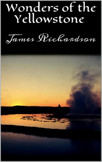
like a gem in the centre of this snow-rimmed crown of the continent,
is the loveliest body of fresh water on the globe, its dark-blue
surface at an elevation greater than that of the highest clouds that
fleck the azure sky of a summer's day, over the tops of the loftiest
mountains of the East. Its waters teem with trout, and the primeval
forests that cover the surrounding country are crowded with game. But
these are the least of its attractions. It is the wildness and
grandeur of the enclosing mountain scenery, and still more the
curious, beautiful, wonderful and stupendous natural phenomena which
characterize the region, that have raised it to sudden fame, and
caused it to be set apart by our national government as a grand
national play-ground and museum of unparalleled, indeed incomparable,
marvels, free to all men for all time.Evidences
of ancient volcanic action on the grandest scale are so abundant and
striking throughout the lake basin, that it has been looked upon as
the remains of a mammoth crater, forty miles across. It seems,
however, to have been rather the focus of a multitude of craters. "It
is probable," says the United States geologist, Dr. Hayden, with
his usual caution, "that during the Pliocene period the entire
country drained by the sources of the Yellowstone and the Columbia
was the scene of volcanic activity as great as that of any portion of
the globe. It might be called one vast crater, made up of a thousand
smaller volcanic vents and fissures, out of which the fluid interior
of the earth, fragments of rock and volcanic dust, were poured in
unlimited quantities. Hundreds of the nuclei or cones of these
volcanic vents are now remaining, some of them rising to a height of
10,000 to 11,000 feet above the sea. Mounts Doane, Longford,
Stevenson, and more than a hundred other peaks, may be seen from any
high point on either side of the basin, each of which formed a centre
of effusion."All
that is left of the terrific forces which threw up these lofty
mountains and elevated the entire region to its present altitude, now
finds issue in occasional earthquake shocks, and in the innumerable
hot springs and geysers, whose description makes up so large a
portion of this book of wonders. Nowhere else in the world can the
last-named phenomena be witnessed on so grand a scale, in such
limitless variety, or amid scenes so marvellous in beauty, so wild
and unearthly in savage grandeur, so fascinating in all that awes or
attracts the lover of the curious, the wonderful, the magnificent in
nature.
CHAPTER II.
FIRST
EXPLORATIONS.In
their exploration of the headwaters of the Missouri in the summer of
1805, the heroic Captains Lewis and Clarke discovered and named the
three terminal branches of that river—the Jefferson, the Madison,
and the Gallatin; then ascending the first named to its springs among
the Rocky Mountains, they crossed the lofty ridge of the divide and
pursued their investigations along the Columbia to the sea. The
following summer they returned, separately exploring the two main
branches of the Great River of the Northwest, each perpetuating the
name and fame of his brother explorer by calling a river after him.
Ascending the southern, or Lewis Fork, Captain Clarke recrossed the
mountains to Wisdom River, (a branch of the Jefferson,) then
traversed the country of the Jefferson, the Madison and the Gallatin
to the Rochejaune, or Yellowstone, which he followed to its junction
with the Missouri, where he rejoined Captain Lewis. The map of the
country explored by these brave men, makes the source of the
Yellowstone a large lake, doubtless from information received from
the Indians, but they seem to have heard nothing of the marvels along
the upper reaches of the river and around the lake from which it
flows.In
later years—especially after the discovery of the Montana
gold-mines had drawn to the upper valleys of the Missouri an
adventurous, gold-seeking population, who scoured the mountains in
all directions—rumors of burning plains, spouting springs, great
lakes and other natural wonders, came down from the unknown regions
up the Yellowstone. And not content with these, the imagination was
freely drawn on, and the treasure valleys of the Arabian Nights were
rivalled, if not reproduced. Our over-venturous party, hotly pursued
by Indians, escaped, report said, by travelling night after night by
the brilliant light of a huge diamond providentially exposed on a
mountain. A lost trapper turned up after protracted wandering in this
mysterious region, his pockets stuffed with nuggets of gold gathered
in a stream which he could never find again. More astounding still
was a valley which instantly petrified whatever entered it. Rabbits
and sage-hens, even Indians were standing about there, like statuary,
among thickets of petrified sage-brush, whose stony branches bore
diamonds, rubies, sapphires, emeralds and other gems by the thousand,
as large as walnuts. "I tell you, sir," said one who had
been there, to Colonel Raynolds, "it is true, for I gathered a
quart myself and sent them down the country."The
first earnest attempt to explore the valley of the upper Yellowstone
was made in 1859, by Colonel Raynolds, of the Corps of Engineers. His
expedition passed entirely around the Yellowstone basin, but could
not penetrate it. In his report to the War Department, he says:"It
was my original desire to go from the head of Wind River to the head
of the Yellowstone, keeping on the Atlantic slope, thence down the
Yellowstone, passing the lake, and across by the Gallatin to the
three forks of the Missouri. Bridger said at the outset that this
would be impossible, and that it would be necessary to cross over to
the headwaters of the Columbia and back again to the Yellowstone. I
had not previously believed that crossing the main crest twice would
be more easily accomplished than the transit over what was in effect
only a spur; but the view from our first camp settled the question
adversely to my opinion at once. Directly across our route lies a
basaltic ridge, rising not less than 5,000 feet above us, its walls
apparently vertical, with no visible pass or even cañon. On the
opposite side of this are the headwaters of the Yellowstone. Bridger
remarked triumphantly and forcibly on reaching this spot, 'I told you
you could not go through. A bird can't fly over that without taking a
supply of grub along.' I had no reply to offer, and mentally conceded
the accuracy of the information of 'the old man of the mountains.' *
* * * *"After
this obstacle had thus forced us over on the western slope of the
Rocky Mountains, an effort was made to recross and reach the district
in question, but although it was June, the immense body of snow
baffled all our exertions, and we were compelled to content ourselves
with listening to marvellous tales of burning plains, immense lakes,
and boiling springs, without being able to verify these wonders. I
know of but two white men who claim to ever have visited this part of
the Yellowstone Valley—James Bridger and Robert Meldrum. The
narratives of both these men are very remarkable, and Bridger, in one
of his recitals, described an immense boiling spring, that is a
perfect counterpart of the Geysers of Iceland. As he is uneducated,
and had probably never heard of the existence of such natural marvels
elsewhere, I have little doubt that he spoke of that which he had
actually seen. The burning plains described by these men may be
volcanic, or, more probably, burning beds of lignite similar to those
on Powder River, which are known to be in a state of ignition.... Had
our attempt to enter this district been made a month later in the
season, the snow would have mainly disappeared, and there would have
been no insurmountable obstacles to overcome."I
cannot doubt, therefore, that at no very distant day the mysteries of
this region will be fully revealed, and though small in extent, I
regard the valley of the upper Yellowstone as the most interesting
unexplored district of our widely expanded country."Ten
years after Colonel Raynolds's unsuccessful attempt to solve the
problem of the Yellowstone, a small party under Messrs. Cook and
Folsom ascended the river to the lake, and crossed over the divide
into the Geyser Basin of the Madison. No report, we believe, was
published of their discoveries. At any rate, the general public were
indebted for their first knowledge of the marvels of this region to
an expedition organized in the summer of 1870 by some of the
officials and leading citizens of Montana. This company, led by
General Washburn, the Surveyor-General of the Territory, and
accompanied by a small escort of United States cavalry under
Lieutenant G. C. Doane, left Fort Ellis toward the latter part of
August, and entered the valley of Yellowstone River on the 23d.
During the next thirty days they explored the cañons of the
Yellowstone and the shores of Yellowstone Lake; then crossing the
mountains to the headwaters of the Madison, they visited the geyser
region of Firehole River, and ascended that stream to its junction
with the Madison, along whose valley they returned to civilization,
confident, as their historian wrote, that they had seen "the
greatest wonders on the Continent," and "convinced that
there was not on the globe another region where, within the same
limits, nature had crowded so much of grandeur and majesty, with so
much of novelty and wonder."Mr.
Langford's account of this expedition, published in the second volume
of Scribner's
Monthly, and the
report of Lieutenant Doane, printed some time after by the United
States Government, (Ex. Doc. No. 51, 41st Congress,) gave to the
world the first authentic information of the marvels of this
wonderful region. Though their route lay through a terrible
wilderness, and most of the party were but amateur explorers at best,
only one (Mr. Everts) met with a serious mishap. This gentleman's
story of his separation from the company, and his thirty-seven days
of suffering and perilous wandering, is one of the most thrilling
chapters of adventure ever written.The
path fairly broken, and the romance of the Yellowstone shown to have
a substantial basis in reality, it was not long before others were
ready to explore more fully the magnificent scenery and the strange
and peculiar phenomena described by the adventurers of 1870. As soon
as the following season was sufficiently advanced to admit of
explorations among the mountains, the Chief Engineer of the Military
Department of the Missouri, Brevet Colonel John W. Barlow, set out
for a two months' survey of the Yellowstone Basin, under special
orders from General Sheridan. His route lay along the river to the
lake; thence along the northern shore of the lake to the hot springs
on its western bank; thence across the mountains westward to the
Geyser Basins of Firehole River, which he ascended to its source in
Madison Lake; thence to Heart Lake, the source of Snake River; thence
across the mountains to Bridger's Lake, in the valley of the Upper
Yellowstone. Descending this stream to where it enters Yellowstone
Lake, he returned by the east shore of the lake to Pelican Creek;
thence across the country to the Falls of the Yellowstone; thence
over the mountains to the East Fork of the Yellowstone, which he
followed to its junction with the main stream.In
the meantime, a large and thoroughly-organized scientific party,
under Dr. F. V. Hayden, U. S. geologist, were making a systematic
survey of the region traversed by Colonel Barlow. The work done by
this party is briefly summarized by Dr. Hayden as follows:"From
Fort Ellis, we passed eastward over the divide, between the drainage
of the Missouri and Yellowstone, to Bottlers' Ranch. Here we
established a permanent camp, leaving all our wagons and a portion of
the party. A careful system of meteorological observations was kept
at this locality for six weeks. From Bottlers' Ranch we proceeded up
the valley of the Yellowstone, surveyed the remarkable hot springs on
Gardiner's River, The Grand Cañon, Tower Falls, Upper and Lower
Falls of the Yellowstone, thence into the basin proper, prepared
charts of all the Hot Spring groups, which were very numerous, and
continued up the river to the lake. We then commenced a systematic
survey of the lake and its surroundings. Mr. Schönborn, with his
assistant, made a careful survey of the lake and the mountains from
the shore, and Messrs. Elliott and Carrington surveyed and sketched
its shore-lines from the water in a boat. Careful soundings were also
made, and the greatest depth was found to be three hundred feet. From
the lake I proceeded, with Messrs. Schönborn, Peale, and Elliott to
the Firehole Valley, by way of East Fork of the Madison; then
ascended the Firehole Valley. We made careful charts of the Lower and
Upper Geyser Basin, locating all the principal springs, and
determining their temperatures. We then returned over the mountains
by way of the head of Firehole River, explored Madison Lake, Heart
Lake, etc. After having completed our survey of the lake, we crossed
over to the headwaters of the East Fork by way of the valley of
Pelican Creek, explored the East Fork to its junction with the main
Yellowstone, and thence to Bottlers' Ranch, which we reached on the
28th of August. From this place we passed down the Yellowstone,
through the lower cañon, to the mouth of Shield's River, to connect
our work with that of Colonel Wm. F. Raynolds, in 1860. From there we
returned to Fort Ellis."It
is safe to say that no exploring expedition on this continent ever
had a more interesting field of investigation, or ever studied so
many grand, curious and wonderful aspects of nature in so short a
time.