3,59 €
Mehr erfahren.
- Herausgeber: Sandstone Press
- Kategorie: Sachliteratur, Reportagen, Biografien
- Sprache: Englisch
Winner of the Outdoor Writers and Photographers Guild Award for Excellence: Outdoor Book 2019Chris Townsend embarks on a 700-mile walk along the spine of Scotland, the line of high ground where fallen rain runs either west to the Atlantic or east to the North Sea. Walking before the Independence Referendum of 2014, and writing after the EU Referendum of 2016, he reflects on: nature and history, conservation and rewilding, land use and literature, and change in a time of limitless potential for both better and worse.
Das E-Book können Sie in Legimi-Apps oder einer beliebigen App lesen, die das folgende Format unterstützen:
Veröffentlichungsjahr: 2018
Ähnliche


Praise for Chris Townsend
‘I was struck by his thoughtfulness and clear-sightedness – as if all his opinions had been slowly, patiently reasoned out during endless hours of quiet contemplation while alone on the trail.’
Roger Cox, The Scotsman
‘In the Scottish outdoor world names occasionally shine like the stars and very quickly fade into the night. Chris Townsend has remained a shining light for well over 35 years, a passionate and inspiring advocate for the wild corners of our land, an enthusiast who literally walks the walk.’
Cameron McNeish
‘Chris Townsend is the all-around world champion hiking memoirist, guide, photographer, blogger, and techie.’
Ron Strickland, founder of the Pacific Northwest Trail
‘I first met Chris Townsend about thirty years ago cross-country skiing in the Cairngorms. He is someone who practices what he preaches. I have much appreciated his insights and knowledge and he is a great voice for our cause.’
Peter Pearson, Chair of the John Muir Trust
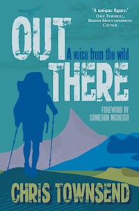
Praise for Out There
‘Townsend has achieved his aim of inspiring others with this book and if you don’t feel like going on a walk – no matter how long or short – after reading it, you never will.’
The Scots Magazine
‘Out There is not just a wonderfully written celebration of backpacking and mountaineering. It’s also a call to arms – a warning that nobody but us will step in to save the wild places we love, and that we all have a responsibility to protect and nurture the environment.’
Alex Roddie
‘What shines through this highly readable anthology is the author’s passionate plea for the protection of our wild country.’
Outdoor Focus
‘Those making the decisions about what happens to wild land would do well to listen to people like Townsend who really understand wild places not for what they are, but for what they can offer.’
Active Outdoors
‘Ranging from the Pacific Crest Trail to the Sierras to the peaks of Britain, Out There is a collection of essays from the many walks of his own life. Brought together, they read as a singular celebration of wild spaces.’
Geographical Magazine
‘Chris is a compelling and engaging author . . . too many delights in its pages to describe in a brief review, I suggest you read and enjoy it.’
Beryl Leatherland, Wild Land News
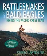
Chris Townsend is possibly the world’s most experienced long-distance walker who also writes. He is the author of many books including Grizzly Bears and Razor Clams, his account of the Pacific Northwest Trail, Rattlesnakes and Bald Eagles, his account of the Pacific Crest Trail, and Out There, which won the Outdoor Writers and Photographers Guild Outdoor Book of the Year Award in 2016. All were published by Sandstone Press. He is gear correspondent for The Great Outdoors magazine and has a website as Chris Townsend Outdoors where his popular blog receives many thousands of visitors.
Also published by Sandstone Press
Grizzly Bears and Razor Clams:Walking America’s Pacific Northwest Trail
Rattlesnakes and Bald Eagles: Hiking the Pacific Crest Trail
Out There: A voice from the wild
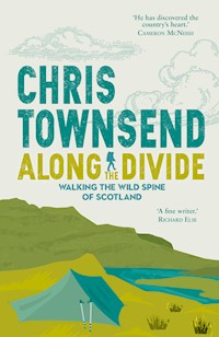
ALONG THE DIVIDE
WALKING THE WILD SPINEOF SCOTLAND
Chris Townsend
First published in Great Britain in 2018
Sandstone Press Ltd
Dochcarty Road
Dingwall
Ross-shire
IV15 9UG
Scotland.
www.sandstonepress.com
All rights reserved. No part of this publication may bereproduced, stored or transmitted in any form withoutthe express written permission of the publisher.
Copyright © Chris Townsend
Editor: Robert Davidson
The moral right of Chris Townsend to be recognised asthe author of this work has been asserted in accordancewith the Copyright, Designs and Patents Act 1988.
The publisher acknowledges support from CreativeScotland towards publication of this volume.
ISBN: 978-1-912240-22-7
ISBNe: 978-1-912240-23-4
Cover and plate sections designed by Raspberry Creative Type, Edinburgh
Typography by Biblichor Ltd, Edinburgh
To Denise
CONTENTS
Acknowledgements
List of Maps
List of Illustrations
1. Beginnings
2. Along the Southern Uplands
3. The Surprising Central Lowlands
4. Stormy Weather to the Great Glen
5. Rain & Sunshine, Deer & Brocken Spectres
6. Last Days in the Mountains
7. The Flow Country
Bibliography
ACKNOWLEDGEMENTS
Peter Wright for inspiring the walk, for all his work on protecting the Watershed, and for his company at the start and finish.
All the people I met along the way for their friendship and interesting conversation and when needed their help.
My partner, Denise Thorn, who, as always, listened patiently to me talking about the book time and time again and who read through the text making many corrections and useful suggestions.
Robert Davidson of Sandstone Press for his help, encouragement and patience.
Heather Macpherson for the cover and the design.
Helen Stirling for the maps.
LIST OF MAPS
Scotland’s Watershed in full
Scotland’s Watershed (south)
Scotland’s Watershed (north)
LIST OF ILLUSTRATIONS
1. Peter Wright on the way to Peel Fell
2. The first day, on Peel Fell in mist and rain
3. The Watershed stretching out through the Border forests
4. Wind flattened trees along the Watershed in the Southern Uplands
5. Dusk near Ettrick Head
6. The Grey Mare’s Tail and Loch Skeen
7. Tussocks, plantations and wind turbines. Tony Hobbs on the Watershed in the Southern Uplands
8. I think that’s clear!
9. The Watershed in the Central Lowlands feels surprisingly remote
10. Vast swathes of cotton grass in the Pentland hills
11. Dusk at camp in the Pentland hills
12. Wind farm in the Central Lowlands
13. St Katherine’s Well
14. The line of the Antonine Wall
15. The Forth and Clyde Canal
16. Looking back to Loch Lomond from the ascent of Ben Lomond
17. The Watershed crosses the West Highland Way near Crianlarich
18. View back to Loch Lomond and Ben Lomond from Beinn Dubhcraig
19. A rainbow brightens the sky after the storm on Ben Lui
20. International Appalachian Trail sign along the West Highland Way
21. Ugly bulldozed track near the Black Corries and Rannoch Moor
22. View across Rannoch Moor from Stob na Cruaiche
23. Signs like this don’t conform with the access legislation
24. Old snowdrift on Ben Alder
25. Beinn Bheoil with Lochan a’Bhealaich Bheithe on the left and Loch Ericht on the right
26. In the Great Glen
27. Beasts in the woods
28. Ruins and plantations in Glen Kingie
29. Antlers in velvet. Red deer stag
30. Fences divide the land. Inside, trees and heather. Outside, bog
31. After a wild night. Camp at Loch a’Bhealaich
32. Jonathan outside Maol Bhuidhe bothy
33. Slioch, Lochan Fada and the Fisherfield hills
34. A hole in the clouds. In the Fannichs
35. In the Fannichs
36. Gleann na Squaib from the ascent of Beinn Dearg
37. A chance meeting with another Watershed walker. David Edgar on Beinn Leoidh
38. Shafts of sunlight, Loch Choire
39. The spread of technology. Signs in the Flow Country
40. View across the Flow Country to Morven
41. Camp in the vast expanse of the Flow Country
42. Almost there. The stacks of Duncansby with the Lighthouse in the distance
43. Finished! Duncansby Head.
1
BEGINNINGS
A watershed, a divide, between two worlds. A raindrop falls, a bog oozes, a trickle begins, running gently downhill, eventually to reach the ocean. Not far away there’s a repeat, in the other direction, maybe heading for a different ocean. Watersheds are significant, dividing the land. Significant enough for us to use them as metaphors for sudden changes in life. ‘A watershed moment’, we say: a moment when something could go either way, in our personal lives, in national or world affairs, with the suggestion that once it happens it cannot be changed, much as the water running downhill can never go the other way.
A watershed is a line that links continuous high ground. Watersheds can be small, just the ridge between two valleys, or can run the length of countries. In Scotland the main Watershed is between the Atlantic Ocean and the North Sea. It’s not a straight line though, far from it. It twists and turns, sometimes heading in what seem perverse directions. Following the Watershed north you can at times find yourself heading south. Scotland is roughly 410 km from south to north. The Watershed covers three times that distance, some 1,200 km. On its journey it crosses the major regions of the Scottish landscape – the Southern Uplands, Central Lowlands, Highlands and the Flow Country. Because Scotland has an overall tilt from west to east the Watershed is mostly towards the west side of the country rather than down the centre, though there are a few wanderings eastwards.
For most of its length the line, convoluted though it may be, is clear. Water either ends up running west into the Atlantic Ocean or east into the North Sea. However, Scotland has a north coast as well as west and east ones. Where is the Watershed there? This is debatable. Peter Wright in Ribbon of Wildness: Discovering the Watershed of Scotland argues it runs to Duncansby Head, the north-eastern point of the mainland, as the Pentland Firth just to the north is where the North Sea meets the Atlantic Ocean. Rivers run north to the latter here, and south-east to the former. You can see the line between these rivers clearly on the map. Follow it exactly on the ground and you’ll cross no running water. David Edgar, who set out to walk the Watershed of Scotland and England and whom I was to meet on my walk, chose Dunnet Head, the most northerly point on the mainland, as the National Hydrographic Organisation says this is where the Atlantic meets the North Sea. Dave Hewitt walked the Scottish Watershed in one continuous journey in 1987, a significant adventure described in his excellent book Walking the Watershed: The Border to Cape Wrath along Scotland’s Great Divide (available online at http://gdl.cdlr.strath.ac.uk/hewwat/), and he reckons anywhere on the north coast will do as the east-west Watershed finishes further south. Resisting the appeal of finishing over the mountains at Cape Wrath I decided that Peter Wright’s view made most sense, even though it meant walking across the boggy Flow Country.
The Watershed isn’t a geographical feature that received much attention until Ribbon of Wildness, Discovering the Watershed of Scotland came out in 2010 and Peter Wright began his enthusiastic and indefatigable campaign to promote its conservation. Before then it was little known though a few walkers had explored it. Mike Allen and Malcolm Wylie had separately walked the whole watershed of mainland Britain in a series of short trips while Martin Prouse walked the Scottish Watershed from Rowardennan to Ben Hope. The only book I knew about it was Walking the Watershed which I read and enjoyed when it was published. I became engrossed in Hewitt’s adventure, but I didn’t gain much of an impression of the Watershed from it. That came much later when I read Wright’s book, which is much more a description of the Watershed rather than the story of an adventure (Wright walked the route in a series of journeys). In fact, so little did I grasp the significance of the Watershed that when I wrote a guide to the Scottish hills (Scotland World Mountain Ranges) I didn’t mention it, an omission that seems astonishing to me now, though I did list Hewitt’s book in the bibliography. Since Ribbon of Wildness was published two runners have done the Watershed, Colin Meek and Elspeth Luke, which is really impressive given how tough some of the terrain is even for walking.
When I read Ribbon of Wildness the idea of a continuous line of wild land stretching through Scotland really sank in and I felt excited and enthused. Walking the Watershed suddenly became something I wanted to do, to see what it was like, to revel in its wildness (hopefully!), and to spend weeks in natural surroundings, camping at night, walking during the day. I would go for the experience, for an unbroken journey, for the joy of being in the wilds for weeks at a time.
This wasn’t the first time the desire to do a long walk had been inspired by a book. Most of my long walks have been. Reading, as well as long-distance walking, is a passion of mine. The words on the page set thoughts racing through my head, make me want to be there, make me want to experience the reality of what the author is describing. When reading Ribbon of Wildness what evoked these feelings was the realisation of how varied the Watershed was and what a long-distance route it could make. I felt that familiar tingle that meant I really wanted to do this walk, to find out what the Watershed had to offer. It almost felt as though this was something I’d been waiting to discover, especially now that I lived in Scotland, having moved from England nearly a quarter of a century ago. It was an opportunity to walk the country from end to end. I had undertaken two long walks in Scotland before. One, a decade before I moved here, was part of my first-ever long-distance walk, from Land’s End to John O’Groats. The other was a round of the Munros and Tops six years after I moved. On neither of these had I been thinking about Scotland itself. Now firmly my home and committed to the country, a Watershed walk would be very different. I saw it as an opportunity to see how the country is connected, how the different parts fit together. And how I felt about it.
It also wasn’t the first time I’d followed a watershed. Twenty-eight years before this walk I’d hiked the Continental Divide Trail, over 4,800 km from Canada to Mexico down the watershed of the USA. On that walk I’d learnt how following a watershed is an excellent way to see a country unfold before you. One place epitomised the Divide for me and really showed just what a country-long watershed is. In the Teton Wilderness in the Rocky Mountains in Wyoming I came to a sign marking the Parting of the Waters where North Two Ocean Creek splits into two little trickling streams, one starting a 5,613-km journey to the Atlantic Ocean, the other heading 2,177 km to the Pacific. There are places on the Scottish Watershed where it is narrow, and you can see water destined for the North Sea on one side and the Atlantic Ocean on the other. I’d been to some of these already but had never realised I was on the Watershed. I was looking forward to returning and seeing the landscape in a different way.
Since moving to Scotland I’d become increasingly concerned about the conservation of nature and wild land and become involved with the conservation movement in Scotland, initially for the Mountaineering Council of Scotland (now Mountaineering Scotland), and, since the walk, the John Muir Trust. Just how wild and unspoilt would Scotland feel if I walked it from one end to the other on the Watershed? What was the potential for Peter Wright’s ‘ribbon of wildness’ to really mean something? Years of looking at wild places, here and abroad, and reading natural history and conservation books meant I knew that nature in Scotland was in a poor condition in too many places. Overgrazing, forestry plantations, industrial developments and more had led to a degraded landscape with poor biodiversity. Once seen and understood this was hard to ignore. American conservationist Aldo Leopold wrote in his seminal book A Sand County Almanac, ‘One of the penalties of an ecological education is that one lives alone in a world of wounds. Much of the damage inflicted on land is quite invisible to laymen.’ Walking down a treeless glen with little wildlife I know exactly what he meant. Maybe I would find a Watershed walk made me sad at what has been lost. At the same time, I knew of all the organisations working on protection and restoration, giving hope that there is a positive future for nature and wildness. Maybe I would see enough to feel optimistic.
I was aware too of the wonderfully named, but really rather sad, idea of ‘shifting baseline syndrome’ by which each generation assumes that the current state of nature is the norm. This can lead to people protecting damaged land rather than trying to restore it or even trying to recreate a damaged landscape. Reading accounts of what forests and wildlife were like in earlier centuries, and of the effects of the Clearances and the Coming of the Sheep and then the deer stalking and grouse shooting estates, made me realise that very little of even the best of what I would see on the Watershed would be near what it could be. It was from such reading that I knew how empty and bare too many glens are of people and wildlife, knowledge reinforced by walking overseas in places where nature was much healthier. From a Watershed walk I hoped to gain a bigger overall picture of what was happening. A ribbon of wildness the length of the country would be a big step towards ecological restoration on a landscape scale.
However, despite my awareness of the state of wild land and nature in Scotland, I did expect to enjoy the walk. I wasn’t setting out to have a miserable time. As walking in wild places is my passion, especially for weeks at a time, I expected to mostly feel content and satisfied. Just being out in nature walking and camping every day is enough to lighten my spirits. I hoped for surprises along the way too, surprises that would please and cheer me, wildlife in unexpected places, beautiful light, calmness and peace. I also knew that even when damaged, nature always has something to offer. As the cliché goes: as long as there is life there is hope. Overgrazed land can recover, plantations can turn into more natural forests, wildlife can return. This is the process now known as rewilding. It needs to happen, and on a large scale. The Watershed could be part of this, a corridor linking areas of wild land, a corridor along which species could travel to new areas.
Much of Scotland is scenically beautiful, grand and spectacular despite the ecological deficit. Except in places where the latter really impinged on my consciousness, I was looking forward to spending so much time in the wilds of the Southern Uplands and the Highlands (though I wasn’t so sure about the Central Lowlands). Being in wild places I always find uplifting. There’s no real wilderness in Scotland, of course. Nearly everywhere has been touched by humanity. But land can still be wild and show little visible sign of people’s influence. Scottish Natural Heritage says wild land consists of ‘largely semi-natural landscapes that show minimal signs of human influence’. I hoped and expected to see much of that on the Watershed.
I love walking as a way to see places properly, to see details and subtlety missed at faster speeds, and I love long-distance walking the most because there is time to immerse myself into nature and wild places, time to really feel part of a place. Moving on day after day is also a way to see how the land changes, how changes in the underlying rocks alter landforms, sometimes gradually, sometimes abruptly. As a walk progresses I gain an overall feel for the whole route, for how it’s all linked. This is helped if I have some understanding of how the landscape came to be the way it is. Knowing a little about the geology and geomorphology of the places I walk through adds greatly to my enjoyment, just as being able to identify wildlife and trees and plants does.
As well as the natural history I also like to learn about the human history. The Watershed has few habitations and only one town but there are many signs of human presence and activity going back to Roman times and earlier. I was interested to see just how much remained and how easy it was to understand. The Watershed today is very much what people have made of it, even if that’s only a fence marking an estate boundary.
The effects of long walks can take time to surface. No long walk is ever exactly as expected, at least not for me. It would be boring if one was. During a walk my thoughts and feelings about it develop and change. They continue to do so afterwards, for weeks, months, years. At the same time as I undertook this walk I was also thinking deeply, though often not clearly, about living in Scotland, where I’d moved twenty-four years earlier. This was now my country but what did that mean? How had I changed in that time? Walking the length of the country, and the aftermath of the walk, would stimulate thoughts and feelings that would surprise and disturb me.
The Watershed was not a walk I expected to be easy. There’s no path most of the way – people cross the Watershed, not go along it – and the terrain can be boggy and rough. There are no signposts either. In fact, there are no mentions of the Watershed anywhere along it. The average height is 450 metres but is higher than that through most of the Southern Uplands and the Highlands. If the weather was stormy the wind and rain would be stronger and heavier on the highest ground.
The Watershed runs over forty-four Munros (mountains over 3,000 feet/914.4 metres) and twenty-four Corbetts (between 2,500 feet/762 metres and 3,000 feet/914.4 metres) – the lists were compiled before metric heights were used in Scotland), the highest being 3,776 foot/1,151 metre- Sgurr nan Ceathreamhan, whose name, appropriately, means hill of the quarters, referring to land division. The low point on the Watershed is just 35 metres above sea level at Laggan in the Great Glen, not, as you might expect, at Duncansby Head, where the top of the cliffs is 60 metres above the sea, or somewhere in the Central Lowlands. The Great Glen is narrow and the Watershed spends very little time so low down.
Resupplying is difficult too, especially north of the Great Glen where there were no towns or villages near the Watershed. Actually on the Watershed there is only one town, Cumbernauld in the Central Lowlands. Leaving the route would be necessary for every other resupply, sometimes going quite a distance. That’s always a dilemma on a long-distance walk. Carry more weight in supplies and stay on the route longer or leave it more frequently to resupply but carry less so you can do more miles a day without getting tired. From previous walks I knew that once I was carrying more than ten days’ food my pack would feel really heavy, so I planned on never needing that much.
The Watershed isn’t marked on maps and there’s no guidebook either, though Ribbon of Wildness gives a fairly detailed description of the route. Using that book, I drew the Watershed on the relevant Ordnance Survey maps, twenty-two in all. These I’d send to myself at Post Offices in places where I was planning on resupplying. I also had Ribbon of Wildness on my e-reader. In my journal, a small notebook with waterproof covers as usual, I wrote the names of supply points and the estimated dates of arrival. After that I just had to try and stay fit before I set out, not usually an easy task as there’s always masses of deskwork to catch up with before leaving it behind for a few months.
When undertaking a long walk, I think of it in stages as the final destination always seems too far away in distance and time to be real. Walking 1,000 km sounds much more difficult than walking 100 km ten times. Each section seems feasible. Complete them all and there’s the whole walk.
The Watershed breaks conveniently into five sections, four of them determined by significant and clearly visible geological features – the Southern Upland Fault, Highland Boundary Fault, and Great Glen are long straight lines cutting right across the country. Peter Wright calls each of these sections a march, meaning a boundary or border (from a Scots word derived from the Anglo-Saxon ‘mearc’), a term still used in the Borders. This is appropriate as the Watershed has been a boundary for centuries with many estates, parishes, councils and more using it as such. Today around 70 per cent of the Watershed still forms the boundary between estates. In many places, especially in the Southern Uplands, a fence or wall marks the boundary and thus the line of the Watershed. As Peter Wright says, communities tended to look downhill, away from the highest ground. The Watershed forms a natural boundary.


